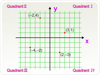
-
A method of defining the position of a point by its perpendicular distance from two or more reference lines.
In plane geometry, two straight lines, called the x-axis and the y-axis, form the basis of a two dimensional Cartesian coordinate system. The x-axis is usually horizontal and the y-axis is perpendicular to it. The intersecting point of the two axes is called the origin (O). Any point on this plane can be identified by an ordered pair of numbers, representing the distances to the two axes. For example, the point (4, 2) is the point that is 4 units away from the y-axis in the positive direction of the x-axis and 2 units away from the x-axis in the positive direction of the y-axis.
In three dimensions, a third axis, the z-axis, is introduced to define the height or depth of a point. All three axes are mutually at right-angles in Cartesian coordinate system. Hence, a point is determined by three numbers (x,y,z).
